Wednesday 18th November 2020 is International GIS day and as such is a great opportunity to reflect and celebrate how advances in GIS in combination with other technological changes have enabled environmental projects to be delivered more efficiently and effectively than ever before. At Thomson Environmental Consultants we utilise GIS technology for multiple purposes, including data capture, spatial analysis and data presentation. GIS routinely supports our consultants with key project tasks, including establishing ecological baselines, assessing the environmental impact of developments and locating appropriate mitigation. The examples below demonstrate how GIS is an integral part of project delivery at Thomson.
Data Capture
GIS has increased the efficiency and ease of environmental data capture out in the field and in some cases removed the need for field surveys altogether. Before mobile data capture on GPS devices, environmental features were located and measured manually, supported by paper field sketches. With GIS apps readily available on GPS-equipped smart phones, the location and extent of features can be captured with an accuracy of up to a few metres (and cm-level accuracy on survey grade devices). It’s possible to deploy bespoke data capture layers and digital survey proformas, tailored to the survey type or specific client requirements, ensuring the required information is collected in a digital format and attached to the geolocated data. With a mobile data connection, GIS data collected in the field can now be uploaded to our GIS server real-time. As a result, survey results can be viewed via web GIS instantaneously, benefitting project managers that need to keep track of survey progress.
Spatial Insights
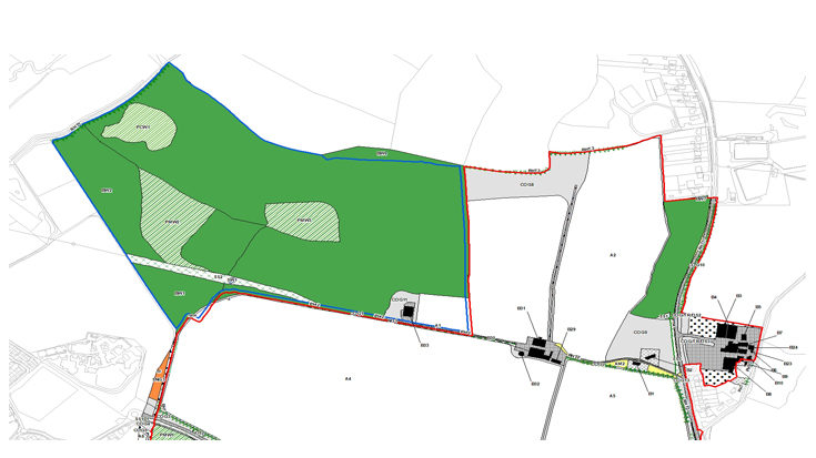
As well as the benefits for mobile data capture, GIS can be hugely beneficial for assessing environmental impacts of projects. Insights can be gained through combining spatial datasets and their attributes. For example, GIS can be utilised for mapping the extent of metapopulations of Great Crested Newts (GCN’s), a European protected species, through combining various datasets together. Buffers can be generated at a set distance around ponds, representing the likely GCN territorial extent. Barriers to GCN movement, such as major roads, can be intersected with the buffer zones and the areas beyond them excluded from the metapopulation area, generating realistic metapopulation areas representing GCN territories. GIS can also be useful for planning and delivering appropriate mitigation, such as identifying suitable ponds for translocation and monitoring the progress of GCN trapping.
Interactive Mapping
With an increasing prevalence of web-based interactive mapping portals, it’s now easier than ever for project teams to view and engage with spatial information relevant to their project. At Thomson, we deploy ‘Thomson Interactive Mapping’ (TIM) sites for our projects, ensuring all members of the project team have access to the same project datasets and that collaboration between project managers and clients is as seamless as possible. With interactive mapping, users can choose which layers they want to view, query attributes and perform basic spatial queries such as distance measurements and area calculations themselves, freeing up our in-house GIS team to perform more complex data processing, visualisation and spatial analyses and giving clients a real opportunity to understand data in new and exciting ways.
GIS has become an integral and essential component of delivering environmental assessments. The increased accessibility of GIS technology over the past decade has provided efficiency gains and opened up new opportunities for collaboration between project teams and clients. Going forward, with GIS tools such as machine-learning and 3D visualisations becoming increasingly available, GIS will continue to drive efficiency gains and offer new insights within the environmental sector, however at the moment we still foresee a continuing need for GIS and Ecology professionals alike to ‘sense check’ automated outputs.